The temperatures hovered around mid-fifties all day with sun and rain coming and going. This was the first day in awhile I didn't purchase any gasoline; whew! I spent the bulk of the day in Seattle visiting the Museum of Flight. There were just about any kind of aircraft one could mention from US Mail carriers, World War I and II fighters, to space travel vehicles. Being inside one could dodge the raindrops also.
I am off tomorrow to board a ferry across the Washington waterways to find more adventures.
I would like to thank Rich for all his hospitality during my stay and to wish Pat a quick recovery from her surgery as I am once again back on the road.
On the road again!
The Traveller
Monday, April 30, 2012
Air Force One

VC-137 where V stands for VIP Transport, C stands for Cargo and 137 is the identification number.
SAM 970 where SAM stands for Special Air Missions and 970 is the last three digits of the tail number.
Air Force One is a temporary call sign used by traffic controllers while it has the President aboard.
This particular Boeing 707 carried many Presidents including Eisenhower, Kennedy, Johnson, and Nixon.
Concorde Supersonic Airliner

Northwestward Bound Ending Day-Day 20
Temperatures were basically in high 50s to mid 60s throughout the day during the drive up North from Tacoma, Washington to the tulip capital of the world in La Connor, Washington. The tulip festival is still in bloom but nearing its end, especially with rain in the forecast for the day. Gasoline purchased today was at $3.999/gallon, not exactly to my liking. Day 20 was kind of a leisurely day.
My plans today are to visit the Museum of Flight in Seattle to try and dodge the raindrops.
Stay loose folks!
The Traveller
My plans today are to visit the Museum of Flight in Seattle to try and dodge the raindrops.
Stay loose folks!
The Traveller
Fort Nisqually Granary

Tacoma Narrows Bridges

Sunday, April 29, 2012
Clouds Get In My Eyes Day-Day 19
Was a real nice day for the most part as I awoke with a temperature of 54F and it did reach a high of 66F in the afternoon. It plummeted to 40F at the top of the drive to Paradise (Mount Ranier viewing station) and as one can see from the picture of the fox it was extremely misty from the clouds I was in. Gasoline prices in Washington are out of this world as I paid $3.999/gallon. One of the locals stated that there are huge taxes (state) added to cause this. I did spend a good deal of time on the road but it was most enjoyable. It seems what ever direction one looks out here there are Mountains. The Northwest is very pleasing to the eye. I will be seeing Tacoma today and then up to the Eitners.
Stay in touch folks!
The Traveller
Stay in touch folks!
The Traveller
For You Animal Lovers

Misty Mount Ranier

The Palisades

Cascade Mountains

BNSF Railway

Saturday, April 28, 2012
Oregon Trail Day-Day 18
The morning temperature was 49F and the afternoon maxed out at 55F and with the wind gusting made for a real cool day. The sun did shine through today to warm it up a bit, however. The $3.759/gallon gasoline price is probably average for the trip so far but it did have an octane rating of 87. I might add that Oregon also has the same law as New Jersey in that one cannot pump there own gasoline. The speed limit on the interstate is 65MPH which does slow one down a bit which was a contributing factor of only adding 250 miles today. I stopped in to the National Historic Oregon Trail Interpretive Center today which outlines the trail of settlers from Missouri to Oregon a journey of over 2000 miles. The Trail just outside Baker City has a small granite marker erected by Ezra Meeker in 1906. Meeker, a pioneer of 1853, retraced the Oregon Trail from West to East and erected markers throughout the route of the Trail. These Trails have become a new passion for me. It is off to the Northwest again today as Mt Ranier beckons me.
Have an enjoyable weekend everyone.
The Traveller
Have an enjoyable weekend everyone.
The Traveller
The Bowen Home

Geiser Grand Hotel

Guess What University
Thursday, April 26, 2012
After The Deluge Day-Day 17
Awoke this morning with the temperature hovering around 55F. The afternoon temperature did get up to 74F but most of the day was overcast and very wet. I spent the bulk of the day driving through torrential rains, especially on Routes 84 and 86. Purchased gasoline twice again ($3.629/gallon and $3.679/gallon) as I drove a little over 400 miles today. I might add the $3.679 was an octane of 87. I have now traveled a total of 5031 miles in the 17 days for an average of 296 miles per day. This past week I have picked up the pace a bit. State count now reads 13 with New York, Pennsylvania, West Virginia, Kentucky, Tennessee, Mississippi, Louisiana, Arkansas, Texas, New Mexico, Colorado, Wyoming, and Idaho. I am approximately 2-3 day ride from the Eitners, depending on the route I take. I am leaning toward stopping off at Mt Ranier on the way up.
Enjoy your Friday everyone!
The Traveller
Enjoy your Friday everyone!
The Traveller
Anne Frank Memorial

Snake River

The Grand Teton's New Day

Wednesday, April 25, 2012
Some Kind of Mountains Day-Day 16
The weather played it straight today basically, as the morning temperature was 62F and rose to 70F in the afternoon. It was quite a bit cloudy today and did rain off and on especially when I was in the Grand Teton National Park. Gasoline purchased today was nearly at the trip low $3.499/gallon. I really liked the Teton Mountain Range and how they were formed. They are one rugged looking Mountains. The scenery and road made for a really nice drive up Route 191 today. I am again heading Northwest tomorrow to search out new treasures that I may and will find.
Say goodnight Gracie!
The Traveller
Say goodnight Gracie!
The Traveller
Oh Give Me A Home....


The Grand Tetons

Tuesday, April 24, 2012
Crazy Weather Day-Day 15
Left Wheat Ridge, Colorado this morning with the temperature near 70F and sunny, left Rocky Mountain National Park with it raining and lightning and temperature at 62F, drove through Willow Creek Pass on route 125 with it snowing and temperature at 40F, drove just South of Rand on route 125 with unbelievable winds, and arrived in Rawlins, Wyoming with it sunny and 80F. I am not sure what other weather conditions can exist. Is this what they call Colorado weather? Today was spent visiting Rocky Mountain National Park (RMNP). One could only travel 16 miles up Trail Ridge Road to Milner Pass on the South entrance to the Park. I remember having this issue two years ago with some of the Northern Parks. As a result the planned route of exiting RMNP through Estes Park had to be changed. The gasoline purchased was priced at $3.899/gallon and $3.599/gallon today.
The plan is to travel further North and West to visit the Grand Tetons and Yellowstone the next few days.
Night everyone!
The Traveller
The plan is to travel further North and West to visit the Grand Tetons and Yellowstone the next few days.
Night everyone!
The Traveller
Continental Divide at Milner Pass

Rocky Mountains National Park

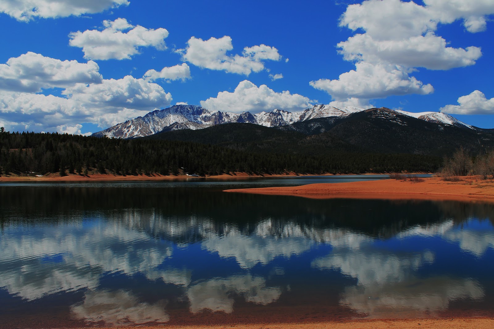
Deja Vu... All Over Again Day-Day 14
The day temperature started out at 68F today and rose to an 84F in the afternoon with sun galore present. These past three days have just been some kind of wonderful especially the weather and scenery. Gasoline was purchased at a Western Station located at the base of Pikes Peak for $3.739/gallon. I am thinking that one of the reason gasoline is less out here is because of the octane rating of 85 versus 87 at home. I continue to pile up the mileage thanks in turn to the 75MPH speed limit in Colorado. I certainly can vouch for John Denver's feeling in the song "Rocky Mountain High". I had that feeling while traveling up to the summit of Pikes Peak. I had the same feeling two years ago when I did the same, only this time I did make it to the top. It is an awe inspiring experience. This time I also got to stop at the U.S. Air Force Academy in Colorado Springs. The Cadet Chapel is some piece of architecture. I asked the ranger about the fox that I encountered the last time I went to Pikes Peak and he said that they have not seen him or her (there were two) for about six months. He was not sure what had happened to them.
The Traveller is off to Rocky Mountain National Park today and then further North and West in Wyoming.
Signing off for now!
The Traveller
The Traveller is off to Rocky Mountain National Park today and then further North and West in Wyoming.
Signing off for now!
The Traveller
Monday, April 23, 2012
Cadet Chapel Interior

U.S. Air Force Academy Cadet Chapel

Pikes Peak View

Crystal Creek Reservoir on Pikes Peak Highway
A Swinging Day-Day 13
This was another good day for the weatherman as the temperature was 54F in the morning and 79F in the late afternoon. There were a few rain showers in the afternoon while traveling through Salida on route 50, however. I purchased gasoline for $3.899/gallon in Walsenburg, Colorado which meant the prices are going in the wrong direction again. This was a very good day of seeing nature's beauty with The Great Sand Dunes, the Mountains, and the Royal Gorge along the route.
Today the plan is to go back up Pikes Peak and to reach the top this time and possible visit US Air Force Academy. Until next time folks!
The Traveller
Today the plan is to go back up Pikes Peak and to reach the top this time and possible visit US Air Force Academy. Until next time folks!
The Traveller
Royal Gorge Bridge

Royal Gorge on the Arkansas River

Sunday, April 22, 2012
Great Sand Dunes Partie Trois

Great Sand Dunes Partie Deux

Great Sand Dunes Partie Un

Saturday, April 21, 2012
Tramway is the only Way Day-Day 12
Another beautiful day today as the temperature was 59F at daybreak and reached a comfortable 80F in the late afternoon. I am hoping this weather keeps up as I am heading into Colorado tomorrow, one of my favorite states for scenic beauty. Gasoline purchased today was for $3.699/gallon, not great but better than $4 at home.
Taking the Tram up Sandia Mountain was an eye popper today. I only wish the photos taken could tell the story of just how beautiful it was. Most of the drive today was again over desolate land. I am glad that I stopped at Fort Union however, as this place shows just how difficult life and travel would have been back then.
Anyways it is on to Colorado tomorrow to see the Great Sand Dunes, stay in touch folks!
The Traveller
Santa Fe Trail

Fort Union National Monument at Watrous, New Mexico

View of Sandia Mountain Range

View From Atop Sandia Peak

Friday, April 20, 2012
Gorgeous Day-Day 11
This was just about the most perfect day for weather as the temperature was 64F in the morning and rose to 75F in the late afternoon with no humidity. What was real surprising was most of the driving was over the Prairie of Western Texas. Gasoline purchased today was a trip low of $3.459/gallon in Lubbock, Texas. Not sure what the prices are back home but I would think that they are dropping some????
I am going to start getting into the Mountains within the next few days, so I am getting a bit excited. Everyone knows what I think of them.
Another busy day tomorrow!
The Traveller
I am going to start getting into the Mountains within the next few days, so I am getting a bit excited. Everyone knows what I think of them.
Another busy day tomorrow!
The Traveller
Billy The Kid Burial Site in Fort Sumner, New Mexico

There is of course a great deal of myths surrounding Billy The Kid.
Buddy and Maria Elena Holly Plaza in Lubbock, Texas

Norm Cash Field in Post, Texas

This was a big surprise to me, while driving up Route 84 from Sweetwater to Lubbock, Texas, I notice Norm Cash Field from the road. As it turned out it was the same Norm Cash that played most of his baseball career with the Detroit Tigers. The Field was dedicated on April 23, 2005 in loving memory of Post, Texas's Most Famous Athlete. Although his lifetime batting average was .271, he did win a Batting Title in 1961 with a .361 average. He originally was drafted by both the Chicago White Sox and Chicago Bears (Running Back) in 1955.
How about that Jim!
Thursday, April 19, 2012
Hit 'Em Up... Move 'Em Out Day-Day 10
The temperature in Texas again hit the 90s mark with a high of 91F. Everyone down here says these are spring temperatures and it soon will hit triple digits. I purchased gasoline this evening in Abilene, Texas for $3.699/gallon, at least it is heading in the right direction.
An update on the mileage to date shows a total of 2627 for an average of 262.7 per day, which is right where I want to be. States visited so far include New York, Pennsylvania, West Virginia, Kentucky, Tennessee, Mississippi, Arkansas, Louisiana, and Texas for a total of nine (9).
The plan tomorrow is to continue heading West, hopefully to add yet another state on the trip.
Going to sleep little doggies!
The Traveller
Texas Longhorns

This picture taken at the Fort Worth Historic District. Their horns can extend to over six (6) feet from tip to tip. As one can see from the photo, there are many different color and horn shapes on the longhorns.
Fort Worth Stock Yards

This picture taken in Fort Worth Stock Yards Historic District. This is a remembrance of the livestock market which operated in downtown Ft Worth from 1866 into the 1950s.
Hot! Hot! Hot! Day-Day 9
I woke up this morning to a brisk temperature of 54F and during my tour of Dealey Plaza the temperature rose to 90F in downtown Dallas, Whew! I purchased gasoline twice ($3.799/gallon and $3.829/gallon) today as I drove a total of over 300 miles today. The tour of President Clinton birthplace home, spending a great deal of time at Dealey Plaza which included a tour of the Sixth Floor of what was once known as the Texas School Book Depository Building, and stopping in Arlington to see Cowboys Stadium made for a busy day, but enlightening. Photos were not permitted during the Sixth Floor tour as a security guard was stationed there.
Today is going to be a more leisurely day as I plan to go down to the stockyards in downtown Ft Worth and then head west again.
Tentative plans are that I will be in the state of Washington sometime on or about May 1. I hope this doesn't create any problems with the Eitners.
Take care everyone!
The Traveller
Cowboys Stadium in Arlington, Texas

Located just a stone's throw from the Rangers Ballpark of Arlington is Cowboys Stadium where the Dallas Cowboys play football. I asked to go inside for a picture of the field but was denied. It doesn't hurt to ask though. I was told the front of the stadium is the rectangular shaped screen to the left of the photo. Your over a billion dollar building!!!
Rangers Ballpark in Arlington, Texas

This picture taken in Arlington, Texas which by no coincidence is located between Dallas and Ft Worth areas. The Rangers Ballpark is where the Texas Rangers play baseball. This may be the best team in baseball right now.
Dealey Plaza in Dallas, Texas

This picture taken from Dealey Plaza on Elm Street where President Kennedy lost his life on November 22, 1963. The Warren Commission concluded that the President lost his life as a result of Lee Harvey Oswald stationed at the Sixth Floor window of the Texas School Book Depository Building shown in the rear left building. The Sixth Floor window (shown with arches above windows) is the one all the way to the right. The X on the road marks the spot where it happened.
William Jefferson Clinton Birthplace Home

Although this place was President Clinton grandparents house, it is considered his Birthplace Home. His father Billy Blythe II died in an automobile accident three (3) months prior to his birth and his mother had him move into her parents house for four (4) years while she went back to school in New Orleans.
Tuesday, April 17, 2012
Who'll Stop The Rain Day-Day 8
It rained all night long and then all of the morning while I was finishing up the tour of Vicksburg National Military Park. The 16 mile tour of the Park took a great deal of time to finish totaling about 3.5 hours. The Siege of Vicksburg, which lasted 47 days until July 4, 1863, ended in the surrender of the city to the Union forces.
Gasoline purchased today cost $3.799/gallon, which still does not match the low $3.619/gallon price of the trip.
During the afternoon in or about Monroe, Louisiana the sun came out and the temperature then rose to 78F.
My plan is to go into Dallas tomorrow to Dealey Plaza, see Cowboy Stadium, and whatever else that I deemed interesting.
Until then folks!
The Traveller
Hutchinson Glass Bottle

This picture shows the very first container used to bottle Coca-Cola. In 1894 a candy store owner in Vicksburg, Mississippi, Joseph A. Biedenharn, began bottling Coca-Cola to sell using a common glass bottle called a Hutchinson. Prior to this all Coca-Cola was sold in soda fountains for five cents a glass at the local drugstore.
Fort Garrott from Hovey's Right Approach in Vicksburg National Military Park

This picture shows the restored section of the two approach trenches dug by General Alvin P. Hovey's Union Troops. The zigzag design helped to nullify the effects of Confederate enfilading (flanking) fire thus minimizing federal casualties. To the rear left of the picture, one can see Fort Garrott. This was where Confederate Colonel Isham W. Garrott lost his life. There were heavy Confederate casualties there which forced Col. Garrott to engage in the firing himself.
Wexford Lodge (Shirley House)

This picture shows the only surviving wartime structure in Vicksburg Military Park. The Shirley House as it is better known was the home of James and Adeline Shirley. They were both born in the North. Their three children were all born in Vicksburg. Upon the secession of Mississippi from the Union, the Shirleys, who remained supporters of the Union, tried to keep to themselves. During the siege of Vicksburg, the family was forced to flee and take refuge in an empty slave cabin.
Mississip Day-Day 7
The weather was overcast, adding that the temperature never saw 70F today left for a good day of traveling. I did however, get to hear some Delta Blues at Highway 61 Blues Museum, see Deer Creek where Kermit the Frog was born, and to visit part of the Vicksburg National military Park, all located in Mississippi.
The plan today is to finish my tour of Vicksburg Battlefield, it is 16 miles long, and then head West again to Shreveport, Louisiana and then into Texas.
Signing off for now!
The Traveller
The plan today is to finish my tour of Vicksburg Battlefield, it is 16 miles long, and then head West again to Shreveport, Louisiana and then into Texas.
Signing off for now!
The Traveller
U.S.S. Cairo

The U.S.S Cairo, located on the Vicksburg National Military Park in Vicksburg, Mississippi, was a Union Ironclad River Gunboat that was built to wrestle control of the Mississippi River from the Confederates. On December 12, 1862, the Confederates had different plans for the U.S.S. Cairo as they sunk the ship on the Yazoo River. What is pictured here is what is left of the salvaged ship.
The Birthplace of Kermit The Frog, Leland, Mississippi

This picture shows Deer Creek and Rainbow Connection Bridge, an area where Jim Henson grew up and played during the years 1936-1948. As the story goes he sometimes was joined with Kermit Scott a friend of his. The rest is history. There is also a 'Kermit' Museum where there is a letter signed by Jim Henson "Leland, Birthplace of Kermit The Frog". One can also see the Rainbow Connection Bridge sign in the photo. This was dedicated on September 24, 2011 as part of the now annual Leland Frog Festival.
Delta Blues Musicians Mural in Leland, Mississippi

Known as Highway 61 Blues, this mural depicts musicians from the Leland area, including Jimmy Reed, Little Milton, Eddie Cusic, Willie Foster, and James "Son" Thomas. The mural was painted by Delta artist Christian Craven Barnard and Jay Kirgis in 2000. Pat Thomas son of "Son" Thomas actually played a blues tune while I was visiting the Highway 61 Blues Museum.
Sunday, April 15, 2012
Memphis Blues Day-Day 6
Well I asked for warmer weather and am I getting it. Today's temperature topped out at 87F. The Boss said it best 'Waitin' on a Sunny Day' and voila it was here. Although I only drove 126 miles today, gasoline was purchased at $3.779. One can add Mississippi to the 70 MPH speed limit states. The last four states that I have visited have the 70MPH tag.
It was a very enlightening day today on the two stops at Sun Studio and Lorraine Motel in Memphis. Memphis should be on everyone's list of vacation stops.
It is off to Greenville and Vicksburg tomorrow to see Kermie and some Civil War history.
Say goodnight David!
The Traveller!
It was a very enlightening day today on the two stops at Sun Studio and Lorraine Motel in Memphis. Memphis should be on everyone's list of vacation stops.
It is off to Greenville and Vicksburg tomorrow to see Kermie and some Civil War history.
Say goodnight David!
The Traveller!
Lorraine Motel - April 4th, 1968

This picture taken from James Earl Ray perspective, the man found guilty of ending Martin Luther Kings life. Directly behind the red and white wreath on the balcony of the Lorraine Motel is the room (306) that Martin Luther King and Reverend Ralph David Abernathy shared. Notice the two automobiles parked near the Motel, these represent the original automobiles parked in the Lorraine Motel Courtyard. Just to the left of the Motel is the Museum that has an awe inspiring movie of Martin Luther King.
Truly Martin Luther King was worthy of having a national holiday.
Recording Studio at Sun Studio

This picture taken inside Sun Studio where Elvis, Roy, Johnny recorded some of their early hits. The acoustic tiles on the ceiling and walls are the ones used for these recordings. In the late 1980s U2, Def Leppard, John Mellencamp, and Chris Isaak to name a few used this studio to record their tunes. This is history folks, awesome!
Subscribe to:
Posts (Atom)